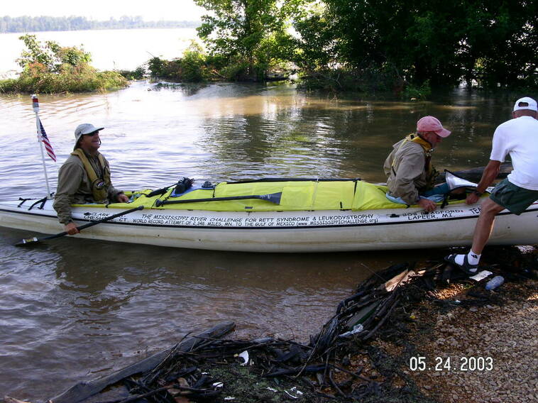
Daily Updates and Pictures,Saturday, May 24, 2003, Day 15 Starts at 6 AM
Mississippi River Challenge for Rett Syndrome and Leukodystrophy, 2003
Guinness Record Setting Event for 2 different rare diseases!
Bob Bradford and Clark Eid - Paddler's Log
Saturday, May 24th, 2003
(BB) Friar's Point feed was difficult to find. It was on river-left at the Mississippi Limestone Corp. Lucky for us that Andrew was up river 400 yards with the laser light and the marine radio. He directed us past a couple parked barges and two tug boats and then left into a landing. Unlucky for me, as I started past the first tug, our bow light went off. The battery was dead and I had to swap batteries before going on. Janet had the night watchman Jimmy Shirley sign a witness form at 3:00 am.
(BB) A riverboat captain and a local person warned us about a dangerous giant whirlpool at mile 644. Clark was paddling and I was sleeping. Clark said he never came across a whirlpool that night.
(BB) During Clark's turn to paddle that night, he figured out what the captains meant when they said "I'll see you on the two" or "I'll see you on the one". On river left (going down river), the navigation lights blink once, then pause. Hence going down river, left bank is the "one" side. On river right (going down river), the navigation lights blink twice, then pause, so it is referred to as the "two" side. Saying you are going to pass a boat on the "one" then means that you are going to stay close to the left bank when going down-river, or the right bank if you are going up-river. Needless to say, Clark and I picked up on this jargon immediately. I believe sometimes the other captains at first thought we were tug captains when we came on channel 13 speaking their language.
(BB) Somewhere around river mile 640 while I was sleeping, Clark had a captain tell him that he'd better cut inside the red buoys because he was going to be crowding the buoys himself. The captain said in fact he may even run over some of them. Clark said that he would like to oblige the captain but that he wasn't even sure where the red buoys were. Clark decided that rather than wait for explanations he would just head for the tree line. Clark told me that it looked like the riverboat captain was actually coming through a flooded cornfield after him.
(BB) Clark had to call the radio station again at 7:30 am but they kept putting him on hold once again, and finally he had to hang up on them.
(BB) We passed Sunflower Cut at river mile 625. This time the Island was under water and there was nothing but a wide river.
(BB) We had a feed at Dennis landing, river mile 609, on river-left.
(BB) At Scrub Grass Bend, we had to cut to the inside of the left hand turn at river mile 600. In 2001, Verlen and I had done the same. During that race we actually hit the last wing dam around the bend. This time we had no such problem. The water level was a lot higher.
(BB) Just below Rosedale gauge, Janet and Mike paddled along with us for the 29-mile stretch to Uncle Joe's landing. They had brought us ice water and snacks.
(CE) This was a fast section of the river, and the weather was calm and hot. It was great to have Janet and Mike along, and to have a supply of ice to keep our jugs charged with. Mike also gave me a bag of homemade jerky that I quickly ate, quenching my lust for salt for a little while. Bob had got some suntan lotion on his paddle, making it sticky, so Mike swapped paddles with him. I suggested that he try rubbing some cooking oil on the shaft, followed by dish soap. (It was an old trick I've used to clean paintbrushes.) I think it worked for him, too. Bob went down for a nap in the heat, using the electric fan to keep the air moving under the deck.
(BB) It was very hot when we got to Uncle Joe's landing at 2:40 pm, at river mile 562. Stan had found a locked gate on the road going back to the landing but had talked the guard, Alvin Morris, into unlocking it and letting them drive back to the feed. The grass was high and the bugs were bad, too. Clark took a shower behind Stan's trailer and I took a solar shower behind the van. The guard Alvin came back to meet us and to sign a witness form.
(CE) Alvin Morris, the guard at uncle Joe’s landing, told us the history of the area, and the hunting club there the name of the hunting club, which I don’t recall, was in remembrance of a dyke breach there many years ago (27 Break Club) at mile 563). The grass was tall and there were a lot of prickly bushes to walk through.
(BB) Around 7 pm, we paddled into the landing at the Greenville Bridge. The city of Greenville is in Mississippi but we pulled in just above the bridge on the Arkansas side of the river. The landing was flooded and our crew could not drive back to the landing because other access road had a river flowing across it in two places. Each place was under knee-deep water. Mike, Denise, Angie, and Justin had walked back to the landing through the water and brought us our food. We met a man named Donnie McKinney there. He was fishing and let Justin hold up the fish that he had caught. Justin also found and caught a frog while waiting for us. He later took the frog all the way back to show his grandma before letting it go.
(BB) They were building a new bridge just below the one at Greenville. Once we left the bridge, Clark went down for his nap. I crossed the river over to the left side down by Walnut Point Light at mile 522.5.
(BB) It was really dark that night and the river was much wider than normal due to flooding. I think that all of Kentucky Bend Bar was under water at river miles 518 to 516. I stayed close to the left bank so that I would not get behind any sand bars. At or near river mile 507, Clark got up to give me a hand. I had one up-bound tug coming at me and two southbound tugs behind. At river mile 503, the river turns left and it narrows a lot. I talked to the tug captain behind me and asked if he could see me. He said yes and that we were not in a very good spot. Our road crew was waiting for us about 5 miles below at Mayersville Miller landing. Although they could not hear any of our transmission, they could hear the captain's response. Needless to say the crew was a little bit concerned.
(CE) I got up from by nap near Kentucky Bend, around 9 pm after a couple hours of sleep. The river was flowing fast as we passed through Cracraft Chute.
(BB) After the captain told us we were in a bad spot, we decided to stay all the way to the right shore. The captain had no idea that we could move so fast and told us that we were well out of his way. We found ourselves rather close to Oppossum Point Lower light at river mile 502.5. We were actually paddling up stream and trying to keep from being sucked down into an even narrower position of the river. I thought that we were doing rather well because I notice that we were passing lots of logs, but Clark found our otherwise. He had been keeping an eye out for Opossum Point Light. He also noticed that we were actually going down river instead of up. We paddled harder and got closer to the shore and into the edge of a back eddy. The tug passed and Clark and I turned around to follow him.
(BB) It was near there when the next river captain questioned us about what kind of a craft we were in. When I told him that we were in a canoe, he said we must have “sh** for brains”. I thought I had misunderstood him but when he repeated it for a second time I found that I had not. This captain was the only rude captain that we ran into during our entire trip.
(CE) We had the audio recorder on while we talked over the marine radio. The tug captain’s remarks were recorded, reminding me of a similar conversation in 2001 near New Orleans, when a tug captain asked if we “were the first drops in a flood of idiots”. I’d get angry, but at the same time think about their perspective, and that maybe they were right.
(BB) Our road crew met us at the Miller Landing Grain elevator, river mile 497. They had planned on meeting us below, at the tennis court, but it was flooded at Mayersville, MS. The grass was rather tall and the bugs were very bad. We couldn't tell that was us but something sure was. When we got back into the water it was my turn to sleep.
(BB) Our road crew met us at the Miller Landing Grain elevator, river mile 497. They had planned on meeting us below, at the tennis court, but it was flooded at Mayersville, MS. The grass was rather tall and the bugs were very bad. We couldn't tell that was us but something sure was. When we got back into the water it was my turn to sleep.
|
Approximate Location
Weather
Forecast for Greenville, Mississippi, where the paddlers are this evening:
Tonight. Mostly cloudy. A chance of showers and thunderstorms in the evening then showers and thunderstorms likely with locally heavy rainfall after midnight. Lows in the mid 60s. Southeast winds 5 to 10 mph. Chance of rain 60 percent.
Sunday. Cloudy. Showers and thunderstorms likely with locally heavy rainfall. Highs in the upper 70s. West winds 10 to 15 mph. Chance of rain 60 percent.
|
Text Updates from our Race Web Log During the race
Saturday, May 24, 2003 posted by Mary at 7:42 AM Flood info from the National Weather Service for the Greenville, Mississippi area: RIVER FLOOD WARNING REMAINS IN EFFECT FOR: ...THE LOWER MISSISSIPPI RIVER AT ARKANSAS CITY...GREENVILLE... NATCHEZ... FOR THE MISSISSIPPI RIVER NEAR GREENVILLE, MINOR FLOODING IS OCCURRING, WITH A STAGE OF 49.2 FEET MEASURED AT 7 PM FRIDAY. THE RIVER IS CURRENTLY CRESTING AND IS FORECAST TO BEGIN SLOWLY FALLING TOMORROW. WATER LEVELS HERE ARE NOT EXPECTED TO DROP BELOW FLOOD LEVELS FOR AT LEAST SEVERAL DAYS. FOR THE MISSISSIPPI RIVER AT NATCHEZ, THE LATEST STAGE WAS 47.0 FEET AT 7 PM FRIDAY. FLOOD STAGE IS 48.0 FEET. MINOR FLOODING IS FORECAST, WITH A CREST OF 48.5 FEET, EARLY TUESDAY MORNING. THE RIVER IS FORECAST TO RISE ABOVE FLOOD STAGE AROUND 7 AM SUNDAY. AT 48.0 FEET, CARTHAGE POINT ROAD BECOMES IMPASSABLE AND WATER BEGINS TO AFFECT APPROXIMATELY 100 HOMES IN DEAR PARK. Mary Potter _____________________________________________ posted by Mary at 7:46 AM If the National Weather Forecast is correct, looks like the team may get caught in some thunderstorms tonight, tomorrow, and maybe Monday.... we'll have to keep a look out on the weather .... _____________________________________________ posted by Mary at 8:05 AM Clark is calling and said Bob is an animal and paddling 10 mph while he talking on the phone... Go Bob! Clark says he might have some more coffee and let Bob paddle some more, heh heh ... Clark said they are in the channel "paddling where they should be" but because of the floods they are seeing tugs go over where the land is.... he said it's a little scary as the tugs are not where they should be..... Clark said the tugs are pushing large barges as they are going over the land areas.... the good thing is if Bob and Clark are away from the barges they don't have to worry about wake and getting out of the way.... the downside is being surprised, especially in bad weather, fog or during the night...... Clark said Bob really is going 10 mph paddling solo, he was not making that up... the current is moving fast. The crest of the flood is slightly ahead of them, maybe 12 hours or so... I relayed that to him and he told Bob. This makes them happy for some reason.....they seem to think they are going to catch that crest. In the mean time, they are riding the wave. Very lucky for them right now. I asked Clark when he paddles with Bob how fast they can go. He said just a couple more miles per hour at most.... like up to 12. He said there is a maximum cruising rate for this boat.... I warned him of impending thunderstorms tonight and tomorrow in the Greenville area, which they are heading towards (I would guess 10 to 12 hours out.... but don't hold me to that). Clark did call into News 8 in CT (their request) to have a morning live interview, only to be told - oh, they want to do that tomorrow. So Clark will call them tomorrow. We expect the live interview tomorrow between 8 and 9 AM. I'll watch again....and alert all the local CT folks.... Clark said they both got a good sleep cycle in last night, weather is calm, current is fast, and the wind has been worse in the day so they both need to be up for that generally. Clark said he had to go, no point in letting Bob have all the fun... Mary Potter _____________________________________________ posted by Desiree at 9:46 AM Go Team Hope- Yesterday after the frantic flying metal escapade during which I was talking to Stan while the metal came flying into Janet's gas tank, I proceeded to notify all of the Memphis news stations that the team was coming through! Ya'll are going way to fast for media to catch up with. Now my dilemma is whether to go join the road crew, or stick back and get some live press coverage here in New Orleans. I've been working on it but so far no bites. Ya'll better slow down because we are painting some big signs for your arrival. I'm so proud of the team and glad you are finally here in the sunny south. good luck-Desiree |
posted by Dana at 9:53 AM
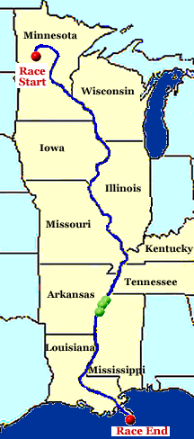
At some unstated time last night, the paddlers and crew met at Friar's Point, river mile 652, for all of 15 to 20 minutes. Their next meeting spot was at Dennis Landing, rivermile 610, where Bob & Clark arrived at 9am. When Clark & Bob left Dennis Landing at 9:20am, Mike and Janet were paddling with them. Really helps keep their spirits and pace up. They are 17 river miles from Rosedale, where the crew will probably take care of some errands, if they have time ... Bob & Clark are averaging 8mph and will probably be at the next meeting spot in around two hours. After the paddlers left, the rest of the crew discovered that Janet's car has a dead battery again -- thanks to Andrew's electronics. They're great, but a real pain at the same time!
The paddlers' time over the next few days may be affected, as thunderstorms are predicted for the next four days, and winds will be shifting to come from the south. But the river current is still huge, allowing them to average 8 to 9 mph.
In looking ahead on their maps, they were reminded that the stretch between Uncle Joe's Landing (river mile 562) and Vicksburg (RM 437) is 125 river miles -- way too long for the paddlers to go without meeting the crew. They located on the map the town of Mayersville, where there is an abandoned tennis court on the river bank. A nice place to meet, depending on the time of day. Two years ago in the early morning hours, the support crew for Team Kruger was chased by dogs in Mayersville -- they wouldn't let members out of their vehicles. Several hours later, the crew for Double Helix came upon a grocery store in Mayersville whose owner was kind enough to donate food to the group. What a difference a few hours can make!
Last night, Denise (Mike's wife) was taking a hike in the woods. When she came back, she was somewhat shaken. She asked if there were alligators in the area. She held her arms about waist high and quite wide to show the size of the monster she'd seen. Mike hiked back where she'd been and came back with grins. He told her he'd seen the same alligator she had -- but around here, they're known as armadillos! We have discovered a new species! Armigators -- distant cousins of crockologs!! I found it necessary, however, to point out to Stan that there is a town near there called Alligator -- hopefully not named for a particular species of animal!
Dana Hanson
_____________________________________________
posted by Mary at 6:18 PM
Just heard briefly from Clark, once at about 3 PM CST and once at 5:50 PM CST.... the first time they were at Uncle Joe's landing in Mississippi.... Angie and I think Janet were there.... and Clark and Bob, the rest of the crew was on the way... he sounded good, said the weather was overcast but fine...... when he called at 5:50 PM he said they were settling in for their long night paddle and we only spoke for a minute, if that, when he said "I have to go help Bob paddle, I have a job to do here" and laughed..... He said he would call in tomorrow morning again, and they would be looking out for any looming storms tonight ..... Mary Potter
_____________________________________________
posted by Mary at 6:34 PM
The paddlers are over 500 miles ahead of the 1984 record right now. According to the stats, looks like they have over 8 days to go about 540 miles.... let's hope they don't need that much time....(don't want to miss the New Orleans party! on June 1 - Everyone invited!)
An update from the Where Are They Now? page statistics.....
Team Hope (Bradford/Eid)
elapsed distance: 1777 miles
remaining distance: 541.2 miles
average overall speed: 5.10 mph
elapsed time since 6 AM 5.10.2003: 14 days 12 hours 23 minutes
remaining time to beat 1989 World Record: 8 days 21 hours 27 minutes
Mary Potter
_____________________________________________
posted by Dana at 8:05 PM
Stan called this afternoon. The crew was able to take care of errands at Rosedale State Park. Part of the park was under water, but thankfully the facilities they needed were still available -- fill the trailer with water, shower, laundry, leave gifts at the dump station.
When the crew arrived at Uncle Joe's Landing (River Mile 562), the road was blocked with an iron gate which was chained. A sign indicated it was private property belonging to the "27 Break Club." Bill Pullen somehow located a club member and, after some explanation, within a few minutes they had complete access to the landing. The club is named for the levee which broke and flooded the area in 1927. Clark & Bob showed up 45 minutes later. Inhibitions are gone -- Bob showered next to his van and Clark showered next to the trailer. Naked but clean!!! Probably a good thing for them as their close proximity to each other 24 hours a day would likely test their sense of smell, depending on which way the wind is blowing. (Janet even joined Bob in the shower, so all had to turn their heads!) Bob & Clark left Uncle Joe's Landing at 3:30pm.
Their next meeting was at the Greenville bridge (RM 530). The paddlers arrived at 7:10pm. Again there was flooding, and the crew could not get the vehicles close to the landing. In fact, a local individual traversed the road in a small truck, and ended up with water above his bumper and in the cab. As a result, everyone had to help portage all the food and other supplies to our paddlers about 1/4 mile away.
Their next stop will be Mayersville (RM 496) -- at night. We'll have to see which event occurs this evening -- the dogs or the grocery store bonanza!
Clark & Bob are currently 556 miles ahead of world record pace. Stan had to call Mark and Verlen this evening to make sure they were aware of it. Mark said that the Kruger Cruiser hull is not designed to go that fast -- Bob & Clark need to slow down! NOT!!!!!!!!!!
Dana Hanson