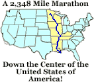
The Mississippi River
|
Mississippi River Excerpts From the National Parks Services (2018):
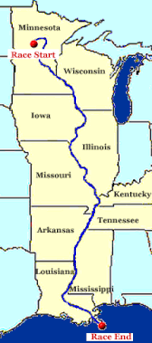
The Mississippi River is the second longest river in North America, flowing 2,350 miles from its source at Lake Itasca through the center of the continental United States to the Gulf of Mexico. The reported length of a river may increase or decrease as deposition or erosion occurs at its delta, or as meanders are created or cutoff. Different lengths may be reported depending upon the year or measurement method. For example, the staff of Itasca State Park at the Mississippi's headwaters suggest the main stem of the river is 2,552 miles long. The US Geologic Survey has published a number of 2,300 miles, the EPA says it is 2,320 miles long, and the Mississippi National River and Recreation Area suggests the river's length is 2,350 miles. At Lake Itasca, the river is between 20 and 30 feet wide, the narrowest stretch for its entire length. The widest part of the Mississippi can be found at Lake Winnibigoshish near Bena, MN, where it is wider than 11 miles. The widest navigable section in the shipping channel of the Mississippi is Lake Pepin, where the channel is approximately 2 miles wide. The speed changes as water levels rise or fall and where the river widens, narrows, becomes more shallow or some combination of these factors. It takes approximately three months for water that leaves Lake Itasca, the river's source, to reach the Gulf of Mexico. Read more on the Mississippi River from the National Parks Services.... Mississippi River Racing by Clark Eid, Updated April 2021 Marathon Paddling Race History World Wide, by Clark Eid, Updated April 2021 Connect with other Mississippi River paddlers:
|
Detailed Charts of the Mississippi
Locks, Dams, Portages
- MN Department of Natural Resources Charts - Headwaters to Minnesota/Iowa Border - Ten mapped segments of the Mississippi River in Minnesota from Itasca State Park
- Upper Mississippi River Charts - from the US Army Corp of Engineers - maps from Minneapolis to Cairo, IL
- Lower Mississippi River - from the US Army Corp of Engineers - Cairo, IL to the Gulf of Mexico
- Maps and Charts, Mississsippi River, Office of the Division Engineer Corps of Engineers, Mississippi Valley Division
- Rivergator.org - THE RIVERGATOR is a mile-by-mile paddler’s guide written for canoeists, kayakers, stand-up-paddleboarders, and anyone else plying the waters of the Lower Mississippi River in human-powered craft. Includes maps/charts
Locks, Dams, Portages
- Wikipedia - Mississippi River Locks and Dams - Lists all Locks and Dams, Links to individual pictures/info
- "Locks & the River" - A Boater's Guide to Travel on the Upper Mississippi River & the Illinois Waterway from the US Army Corp of Engineers - Detailed information about approaching locks and dams, and how to pass through them.
- Maps and Photos of Dam Portages of the Mississippi River by John Sullivan, Updated 2018
Want to know more about the Mississippi River?
- The Great River Road traces the course of the Mississippi River for 3,000 miles through 10 states. Free map, webcam locations, state by state information.
- Mississippi Headwaters Board - Formed in 1980 as an alternative to designation of the river into the National Wild and Scenic River System, the Mississippi Headwaters Board (MHB) works to protect and preserve the first 400 miles of the Mississippi River in Minnesota.
- Upper Mississippi River Conservation Committee - The Upper Mississippi River Conservation Committee (UMRCC), consists of natural resource managers from Illinois, Iowa, Minnesota, Missouri, and Wisconsin. It was created in 1943 to promote a continuing cooperation between conservation agencies on the Upper Mississippi River.
- Lower Mississippi River Conservation Committee - The LMRCC is a coalition of 12 state natural resource conservation and environmental quality agencies in Arkansas, Kentucky, Louisiana, Mississippi, Missouri and Tennessee. It provides the only regional forum dedicated to conserving the natural resources of the Mississippi’s floodplain and focuses on habitat restoration, long-term conservation planning and nature-based economic development. LMRCC staff work out of the U.S. Fish and Wildlife Service’s Lower Mississippi River Fish and Wildlife Conservation Office in Vicksburg, Mississippi
- National Park Service - The River of History - The Historic Resources Study of the Mississippi National River and Recreation Area was developed cooperatively by the National Park Service, and the U.S. Corps of Engineers, St. Paul District in 2003. The historic resources study includes eight chapters, with areas of interest ranging from the early geology of the Mississippi National River and Recreation Area to the growth of many cities along the banks of the river.
- Mississippi River Water Trail - The Mississippi River Water Trail Association (MRWTA) was established through the American Canoe Association and USACE to support and enhance the Mississippi River Water Trail and encourage community involvement.