Daily Updates and Pictures, Thursday, May 22, 2003 - Day 13 Starts at 6 AM
Mississippi River Challenge for Rett Syndrome and Leukodystrophy, 2003
Guinness Record Setting Event for 2 different rare diseases!
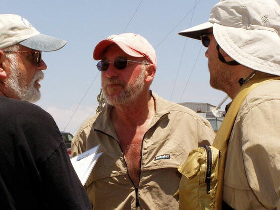 L to R, Capt Stan Hanson, Bob Bradford, Clark Eid, making plans at Hickman, KY, May 22, 2003; Camera - Andrew Gribble
Bob Bradford and Clark Eid - Paddler Log Thursday, May 22nd, 2003; Day 13
(BB) At 12:00 midnight, we arrived at Caster Boat Ramp on river right. I recall when I woke up that I was staring at Clark's headlamp and thought that it was a tug boat coming at us.
(BB) We missed Brown's Chute at river mile 25. It was dark and best not to try it in case the water was too low.
(CE) We were considering taking Brown’s Chute to save some time, but we weren’t sure if there was a shallow wing dam crossing it. Somehow we missed the entrance in the dark so it became a non-issue.
(BB) At Fort Defiance State Park, Stan met us in his Seawind canoe. It was a good thing that he did because we would never have found our feed point. The park was flooded and the water was about 10 feet higher than in the 2001 race. Only the tops of picnic tables and grills were above the water. We had to paddle up the park road almost to where the Mississippi River bridge and the Ohio River bridge meet. We got our meal to go and decided that it would be faster to paddle out the Ohio River than to paddle back down to the Mississippi River. It was just after 9:45 am. The Ohio River was far more flooded than the Mississippi River. Even the pavilion in the park near the point had water standing in it. We were now at mile "O" from the countdown of the upper Mississippi River. The river count now would start at 954 and end at mile "O" in the Gulf of Mexico. We no longer had to do the math in our heads as to how many miles we had left.
(BB) It was sunny and hot and we did not have much wind below the Ohio River that day. Because of the flooded Ohio, we now had a flooded Mississippi
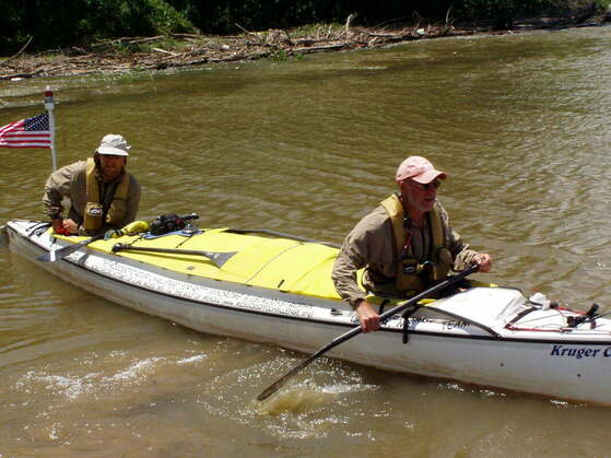 Leaving Hickman, KY, L to R, Clark Eid, Bob Bradford, May 22, 2003; Camera - Andrew Gribble; Mississippi River Challenge for Rett Syndrome and Leukodystrophy, May 2003
(BB) Clark had to make some satellite phone calls to check on his hometown radio stations, employment, and to talk to his wife Mary.
(CE) The river was now moving quickly and there was more barge traffic. One tug blew its horn to alert us to move out of the way. I needed to take a break as Bob paddled to make a call to a company that I had interviewed with a couple weeks before. It was really surreal being on the phone, in a canoe, trying to land a new job. As it turned out, they had hired someone else and I ended up getting another position with another company a couple months later.
(BB) Our crew planned to meet us at Hickman Ferry but it was flooded out. They obtained permission to meet us at Bunge Grain Dock just down river at river mile 922. It was 12:50 pm when we arrived for our meal.
(BB) We caught a lot of head wind going around Winchester towhead where the river goes north for several miles, from river mile 900 to 892.
(CE) Just above New Madrid, on a huge hairpin of the river, a strong upstream wind combined with the downstream current to create a field of “hay stacks”. We had to work our way around these, much like a skier navigates moguls on a ski slope.
(BB) We skipped the feed at New Madrid. It was not only a hard one for our road crew to get to because of the ferry being closed, but it was also a bit of a stretch for us to get to river right and then back to the left in front of New Madrid Bar. Our road crew headed straight to Tiptonville.
(BB) At river mile 884, just after New Madrid bend, it was rough because of barge traffic. The river is over a mile wide by New Madrid's lower dock light.
(BB) It was 7:25 pm when we arrived at Tiptonville Ferry landing. The road was flooded so we had to go just below to a park on river-left. The cornfield that Angie had slept in during the 2001 race was flooded this time and there was actually water running out of the field and crossing the road.
(BB) It was dark corning out of Caruthersville. I didn't remember seeing the big casino on river right in 2001.
(BB) Our crew had planned on meeting us at river mile 840 boat ramp but when they arrived they found that they could only get to a point along the road by Booth's Point at least an eighth of a mile from the main river. We saw the laser light first through the trees and then a riverboat captain directed us to our crew. He told us that they were above the bridge on river left past the tree line in a field. We had a tough time getting through the tree line to the field. It was on an outside bend and the water was moving fast through the brush. We waited until we found an opening and then went left out of the riverbed. We were in an open field through and found that the current was so strong against us that we had to go more down river to a fence line of more trees for protection from the current. We made it OK along the tree line.
(BB) After the feed, Clark stayed up until we got back to the main river and a ways below highway 412 bridge (river mile 839). With all of the high water we were now only about 7 hours behind my crazy schedule. Now it once again seemed possible to not only beat the record but to do it within my 19 day, 15 hour schedule that I had made up prior to the race.
(BB) After the 412 bridge, at river mile 832, a riverboat captain told another captain that he should watch out for a guy on a raft going down river. Clark was asleep so I had the marine radio and I told the captains that I had a canoe and that we were trying to break a world record. During the nights, Clark and I would tune to Channel 13 on the marine band and talk to the tug captains or at least listen to them and see where they were in the river. They would usually give the name of their tug and say whether they were headed North or South and give their river mile. If any tugs were in the area, they would respond and give their info back. They would also note any tricky spots in the river or buoys that may have been out of their location. They also decided which side and where in the river they would pass each other. It was during their communications that they would mention a white canoe in the river with a bright white light on it. They would also mention that we had a marine radio on board if we had talked to them.
END OF PADDLER LOG BY BOB BRADFORD AND CLARK EID, MAY 22 2003
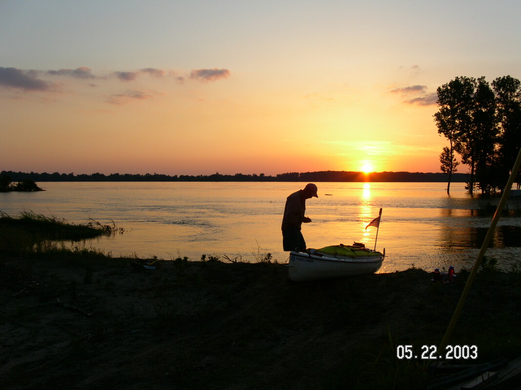
Bob Bradford journaling in Tiptonville, KY, May 22, 2003; Camera used Stan Hanson; Mississippi River Challenge for Rett Syndrome and Leukodystrophy, May 2003
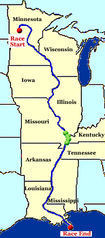 Approximate Location Green Dots
Text Updates from our Race Web Log During the Race May 22, 2003
From Dana Hanson, earlier this morning:
Stan called at 7:15am. The crew was scheduled to meet the paddlers at a boat ramp located at river mile 20. When they got there, however, the area was totally underwater. The crew used the marine radio to contact a tugboat captain who was heading north. He had not seen them or spoken with them, but he was aware that another tugboat located farther north had been in touch with Clark & Bob. With the help of these two captains, eventually Bob & Clark received the word that they should not try to stop at the boat ramp at river mile 20; and that instead, they should head on to Inspiration Point in Fort Defiance State Park.
The crew headed toward the southern-most point of Illinois -- Fort Defiance. There is a nice campground and park there where we stopped during the 2001 race. This is the location of the confluence of the Ohio River and the Mississippi River. The current which is created from the merging of these two rivers is extremely strong. Fort Defiance is only 20 more miles, so the paddlers shouldn't be too tired (hah!) to make it.
Surprise! When the crew got to Fort Defiance and tried to enter the campground, they encountered the first warning sign that things may not be quite right. The road was flooded. They quickly learned there is no campground, as it is under 4 to 5 feet of water. There is no park, because the water is just a couple feet shy of the top of the playground swing sets. There is normally a triangular light on a high stand located at the tip of Inspiration Point to warn boat traffic, but the light is barely above water! Needless to say, there is no place to come ashore! The Ohio River is at flood stage, but has not yet crested. Stan believes that the Ohio River has swelled the Mississippi River downriver to higher levels than it was during 2001. Who knows what's waiting for them!
Janet, Andrew, Bill, and Jon are about 3/4 miles away, just outside the campground. They helped Stan bring his Kruger Seawind down from the top of his car, which he brought for just such an emergency. Stan is in his Seawind and wedged against some treetops in the Mississippi River. (He always wanted to put his canoe in the Mississippi River, but I don't think under these circumstances.) As we spoke, a barge was quickly passing by, creating waves that are always fun to ride out! When they come into view, Stan will begin to frantically wave his orange flag. (Okay, he'll probably just gently wave it back & forth.) The three of them will have to paddle upriver a bit to get to the take-out, but at least the crew found one!
Clark & Bob are expected about 8am. Also expected today, are Angie and Mike (Bob's children), and two of their kids. Angie's Suburban will come in real handy, as Stan has a difficult time sometimes turning around the Expedition with trailer.
And where do they stand right now, you say? Why, only 367 miles ahead of world record pace!!!
posted by Mary for Dana Hanson at 1:50 PM
_____________________________________________
From Dana Hanson, earlier today:
Stan called back at 9:15am. He and his Seawind were able to intercept Bob & Clark just below the bridge at Cairo, Illinois. They've landed, munched down, and are already gone!
As of right now, they are 378 miles ahead, and only 14 hours behind Bob's mad-man schedule! Gaining all the time! Their next meeting spot is the ferry crossing which connects Hickman, Kentucky, and Dorena, Missouri. The planned stop after that is New Madrid, Missouri.
Ya'll get out there and meet them!
posted by Mary at 1:50 PM
______________________________________________
posted by Andrew M. Gribble at 9:11 AM
Bob & Clark arrived Fort Defiance State Park (south of Cairo, IL) at 08h41. Ate a quick breakfast, then departed 08h54. It was quite an eventful night for both paddlers and crew. Details to follow...
Three hundred seventy-eight miles ahead of World Record pace.
AMG
_____________________________________________
posted by Andrew M. Gribble at 12:28 PM
And now...the rest of the story
The evening started pleasantly enough as we were preparing to leave Wittenberg, MO. Twice we have visited the boat ramp of this sleepy little hamlet (once in 2001 and again this year), and twice we have been the recipients of acts of generosity on the part of the residents. In 2001, we were given food for Clark & Kurt's breakfast. This year, some people who stopped by the boat ramp wanted to buy a t-shirt, but didn't have $20 with them. Instead, they gave Bill $17 and went back to their house and filled all of our water jugs, and returned with a supply of onions, lettuce, and brocolli.
The paddlers made excellent time to Cape Girardeau, MO, where we fed them at a boat ramp north of downtown.
The two support vehicles then headed to the Thompson boat ramp, which is in a remote part of eastern Missouri, not far from the Illinois border. A few wrong turns and over an hour later, we found ourselves on a bumpy dirt road a few miles from the boat ramp. All of a sudden a sign appeared which said "road closed." Janet and I went over the levee to check out the reason for the road closed sign. We returned to Stan's vehicle a few minutes later with the bad news: the road was under later. After studying our roadmaps, we could not find any other roads which led to this particular boat ramp. It was clear that we would not be able to get to Bob & Clark at the scheduled location. We then started toward the next closest place where we could reach them: Cairo, Illinois. At Bill's request, we followed a different road rather than going out the way we had come in (the trailer is difficult to back up and turn around, and even more so on a dirt road in the middle of nowhere with no streetlights). We approached Interstate 57 very near where it crosses into Illinois, and started into a tunnel which runs under the insterstate. To our horror we saw that there was water in the tunnel. Would we be able to use this road to get to our destination, or would Bill have to back up over a mile to the nearest place he could turn the trailer around?
Jon Young put on his Chotas (waterproof boots), and walked into the tunnel to check it out. At the other side of the tunnel he gave us the thumbs up signal, indicating that it was safe to continue. On the other side, the single-lane dirt road we had been on turned into a bumpy dirt track. Before long, there was corn (about six inches to a foot tall) growing on both sides of the road. Suddenly there was corn growing IN the road--were we on an actual road, or driving through someone's field? The road became extremely rutted, with a high growth of grass in the middle; so high that it made quite a bit of noise as it scraped the underside of the car, no doubt ridding us of dirt, dust and other debris which had been collecting there since the Mississippi Headwaters. Just when we thought we had seen it all, things got even worse. Mud (and deep car tracks through it) appeared ahead of us. Janet gunned the engine, knowing that she had to keep moving at all costs. Any loss in momentum could send us plunging into the depths of one of those ruts, never to be heard from again. A few skids and a missed heartbeat or two later and we were through, and soon on the relative safety of a regular dirt road again. Stan's car managed to shoot through as well, and we bid goodbye to a road we hope we never have to take again.
We made our way to Fort Defiance State Park (south of Cairo, Illinois), only to discover that the entire park--except for the parking lot near the entrance--was flooded. Stan and Bill waited in the parking lot while Janet, Jon and I went to Wycliff, Kentucky to check out the boat ramp there. No dice. It was extremely flooded, and there appeared to be no easy way to signal the paddlers on the water, nor to guide them in. We returned to the parking lot of Fort Defiance. Stan contacted a couple of Tugboat captains on the marine radio, and asked them to relay a message to a white canoe if they saw it, giving the canoeists our new meeting location (the flooded Fort Defiance State Park at the confluence of the Ohio and Mississippi Rivers).
After the sun came up, Stan paddled through the flooded park in his Sea Wind canoe, and wedged his boat between two trees at the confluence of the two rivers. He waited there for the Bob Clark, who arrived shortly after 08h30. Stan gave them directions through the park to the road where the rest of the road crew was waiting. Bob & Clark landed and got out of the canoe at 08h41. A bathroom break and a quick breakfast followed, and the guys were back in their boat and on the water at 08h54.
We are now in Hickman, Kentucky, where the ferry landing is under water. We have found an alternate meeting spot,and are now discussing what to serve the paddlers for lunch. We expect them here around 13h00.
Mostly sunny skies, windy (winds from the north), and warm (70s).
AMG
_____________________________________________
posted by Andrew M. Gribble at 1:29 PM
Paddlers departed Hickman, KY at 13h19. Next stop: Tiptonville, TN.
AMG
_____________________________________________
Stan Hanson writes:
Verlen, it's your turn to do the dishes.
Everyone on the road crew wishes you and Jenny were here with us.
posted by Andrew M. Gribble at 4:11 PM
_____________________________________________
posted by Mary Potter at 6:42 PM
I got a call today from a nice fellow from the Coast Guard from New Orleans, and gave him Stan Hanson's phone number so he could work directly the team. His main concern was safety, and to alert us to flooded conditions on the Mississippi River, and to assist Team Hope and the paddlers by alerting folks on the river about the paddlers once they were south of the Arkansas border.
His call was primarily safety oriented and I want to take time to let all of you who are watching that both Clark Eid and Bob Bradford paddled the entire Mississippi River in 2001 during record flood waters. Bob and Clark are very experienced paddlers, and have taken great precautions to stay safe and healthy throughout this journey. They have special lights they run with at night, laser lights to signal the road crew with (and vice versa), they carry a marine radio, Globalstar satellite phones and cell phones with them, they wear their life jackets all the time (even when it's really! hot), and have worn their Kokatat dry suits on the open lake crossings when they needed that level of safety.
The road crew as well is very experienced as bank runners and runs as a cohesive group. They are well equipped to call/radio the paddlers directly at any time. Stan Hanson, the road crew captain was the road crew captain for Team Kruger - the team who won the Great Mississippi River Race for Rett Syndrome, May 2001.
The paddlers and road crew also carry multiple sets of duplicate maps and navigation charts, laminated and numbered, marked with information from our previous event in 2001, and marked with "meeting" information.
While I'm sure I'm missing some of the more "technical" details of how well the paddlers and road crew are equipped, I just want to assure anyone reading this that the whole crew has taken significant time to prepare for this event and we have gone the extra mile! when it comes to safety and planning! I have to admit though - if we didn't live in the United States, with the well organized Coast Guard, Army Corp of Engineers, and all the other Emergency Response folks we might need help from in a real emergency, we could not have done this event. Special thanks to all of you out there who are "watching" us and "watching out" for us on these dark nights and long days.
Mary
_____________________________________________
Weather Update added by Mary Potter
Weather for Tiptonville, TN
Tonight. Mostly clear. Lows in the lower 50s. North winds 5 to 10 mph.
Friday. Mostly sunny. Highs in the mid 70s. North winds 10 to 15 mph.
Friday night. Partly cloudy. Lows in the lower 50s. North winds 5 to 10 mph.
FLOOD STATEMENT
NATIONAL WEATHER SERVICE
MEMPHIS TN
958 AM CDT THU MAY 22 2003
THIS IS UPDATED INFORMATION FOR FLOODING ALONG THE MISSISSIPPI RIVER.
MISSISSIPPI RIVER AT TIPTONVILLE...
* FLOOD STAGE: 37.0 FEET
* LATEST STAGE: 38.6 FEET AT 8 AM THURSDAY AND FALLING
* FORECAST: MINOR FLOODING IS OCCURRING. CONTINUE SLOW FALL.
* IMPACT: MOST LOW LYING AGRICULTURE LAND NEAR THE RIVER IS FLOODED.
posted by Mary at 6:17 PM <font>
_________________________________________
posted by Mary Potter at 8:03 PM
Clark just called from Tiptonville, TN, and they are 409 miles ahead of the 1984 record! I told Clark part of the reason they appear to be "surging" ahead is that during the past few "equivalent days" during the 1984 event, very few miles were put on for those days - 69 and 20, according to the chart on our website... tomorrow, "day 14" of the race, the 1984 team put on 111 miles, and averages more tha 110 miles a day after this point. There is even one period between day 18 and day 19 that the 1984 team put on 174.5 miles....
Clark said another thing happening right now is they were catching a crest, and moving very very fast. We did not have much time to talk as the team was calling him to get going after being on land about 5 whole minutes. I asked him if he told them he was busy and buzz off and he laughed. Said he ate chicken and was taking food with him and heading out into the night with Bob.....He sounded good. Not much time to talk though.
Good luck!
Mary